(Kayaking trip Guide)
Milos is a volcanic Greek island in the Aegean Sea, just north of the Sea of Crete. Milos Area also includes the uninhabited offshore islands of Antimilos and Akradies. Milos is the southwesternmost island in the Cyclades group. From east to west it measures about 23 km, from north to south 13 km, and its area is estimated at 151 km² . The greater portion is rugged and hilly, culminating in Mount Profitis Elias 748 m in the west. Like the rest of the cluster, the island is of volcanic origin, with tuff,trachyte and obsidian among its ordinary rocks.
Coastline: - Length of Coast strip -93 км.
- Spectacular volcanic rock formations;
- Sea caves, tunnels and arches;
- Secluded and deserted beaches;
- Uninhabited islands.
(Free and Wild Camping): See Map
- Tsigrado beach - one of the most beautiful south coastal beaches of Milos.;
- Gerontas beach- south coast;
- Agias Yannis bay of west coast-3 beaches;
- Triades bay of west coast - 8 sandy beaches ;
- Agathia beach - the most northerly and remote of the west coast beaches.
- Katsimoutsis beach - northwest coastline.
- Rema beach - the most beautiful of the east coast beaches and it has no land access.
- Firlingos bay - east coast.
- Spathi bay - sheltered bay on the south- eastern coast.
- Paleohori beaches - series of three long sandy beaches of south-eastern coast.
Milos Island - best sightseeing and
public beaches (70) - Kleftico(SW)-spectacular complex of high cliffs, sea passages;
- Sarakiniko(NE) - the most famous place on the island. White rocks and the deep blue sea.
- Best Kayaking Routes : See Map created of Sea Kayak Milos - /domestic Kayak Operator/
- In a North wind:
- 6 day trips routes: East from Kleftiko, Tsigrado, Firligos, Kimolos Island, Klima.
- Paddling Distances: 11 to 16 km.
- Difficulty Level: Moderate.
- In a South/SW wind:
- 5 day trips routes: Arkadia Islands, Sarakiniko, Condaros Bay, Emporios Bay, East coast.
- Paddling Distances: 12 to 14 km.
- Difficulty Level: Easy to Moderate.
- 1 best route in calm or East wind(rare):
- South west coast of Milos.
Milos Island - Nautical Map.
Getting to Milos. Milos can be reached from Piraeus by passenger ferry 4-6 per day in summer. Various ferries service the route. The journey takes 4-7 seven hours depending on the number of islands visited on the way. The cost is 32 euro for the slow ferry and 55 euro for the newer, fast ferries.
Pictures from Milos Coast:
Tsigrado Beach. One of the most beautiful south coastal beaches of Milos. It is a small, dream-like beach, surrounded by high cliffs with wonderful blue waters contrasting with its fine white sand. (Free and wild Camping)

The popular, but remote Gerontas beach and Gerontas Arch - a popular Milos icon.
(Free and wild Camping)

The three beaches of Agias Yannis bay are a classic Milos icon: clear turquoise waters, clean white sands and rugged, colourful cliffs.The west coast beaches are free of crowds, even in peak season. (Free and wild Camping)
 One of the 8 sandy beaches of Triades bay. (Free and wild Camping)
 Rema -the most beautiful of the east coast beaches and it has no land access. A big shady tree behind the beach makes a nice picnic spot! (Free and wild Camping)
 Firlingos bay and Sulphur mines. (Free and wild Camping)
 Spathi bay - sheltered bay on the south-eastern corner of Milos. (Free and wild Camping)
 Kleftico-spectacular complex of high cliffs, sea passages. South-west coast of Milos.
 Sarakiniko the most famous place on the island. White rocks and the deep blue sea.
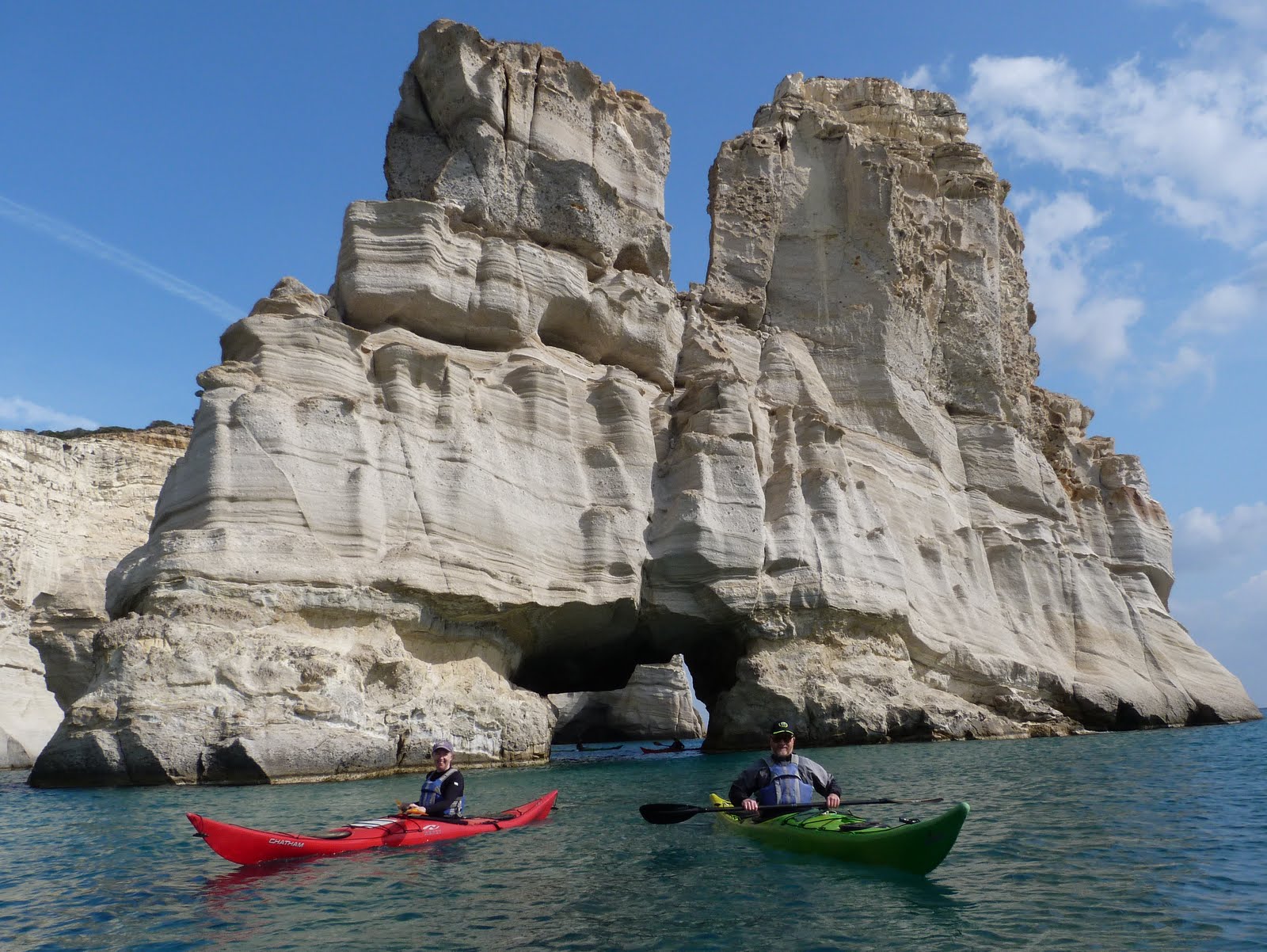
 The Bears.
 Arkadia Islands
 The Weather in Milos
Milos experiences a typical eastern Mediterranean climate; long dry summers, short wet winters and relatively warm waters, year round:-
The Weather in Milos
Milos experiences a typical eastern Mediterranean climate; long dry summers, short wet winters and relatively warm waters, year round:-
Average monthly weather statistics for Milos in degrees Celsius.
J F M A M J J A S O N D Maximum temperature (oC) 14 14 15 19 23 27 29 29 26 22 19 15 Minimum temperature (oC) 9 9 10 12 16 20 22 22 20 17 12 10 Sea temp at 2pm (oC) 14 14 15 17 19 22 24 23 23 20 18 16 No. of rainy days 15 10 10 7 4 2 0 0 2 7 10 15 Hours of sunshine (per day) 3 3 5 9 11 13 14 13 11 9 5 3 <-Ideal swimming temp. ->
<----------Perfect paddling conditions ----->
The Sea Conditions
As the Mediterranean is a closed sea, there is no ocean swell and negligible tide. Together with the warm water temperatures, the conditions much easier and safer to paddle than oceanic conditions.
The wind is the dominant factor affecting sea conditions and it can be strong and persistent at any time of the year. When the wind blows up, it usually persists for 2-5 days, then dissipates for about the same. There is little variation in the wind strength throughout the day; if its windy in the morning it will be windy all day. When its not windy the sea is dead calm. On strong wind days sheltered waters can be found on the lee side of the island.
Wind direction and strength are predicted very accurately. The site I find most reliable is the 8 day forecast on -http://www.weatheronline.co.uk
Most Pictures , maps and facts are taken from Sea Kayak Milos.
The popular, but remote Gerontas beach and Gerontas Arch - a popular Milos icon.
(Free and wild Camping)
The three beaches of Agias Yannis bay are a classic Milos icon: clear turquoise waters, clean white sands and rugged, colourful cliffs.The west coast beaches are free of crowds, even in peak season. (Free and wild Camping)
One of the 8 sandy beaches of Triades bay. (Free and wild Camping)
Rema -the most beautiful of the east coast beaches and it has no land access. A big shady tree behind the beach makes a nice picnic spot! (Free and wild Camping)
Firlingos bay and Sulphur mines. (Free and wild Camping)
Spathi bay - sheltered bay on the south-eastern corner of Milos. (Free and wild Camping)
Kleftico-spectacular complex of high cliffs, sea passages. South-west coast of Milos.
Sarakiniko the most famous place on the island. White rocks and the deep blue sea.
The Bears.
Arkadia Islands
The Weather in Milos
Milos experiences a typical eastern Mediterranean climate; long dry summers, short wet winters and relatively warm waters, year round:-
Average monthly weather statistics for Milos in degrees Celsius.
| ||||||||||||
| J | F | M | A | M | J | J | A | S | O | N | D | |
| Maximum temperature (oC) | 14 | 14 | 15 | 19 | 23 | 27 | 29 | 29 | 26 | 22 | 19 | 15 |
| Minimum temperature (oC) | 9 | 9 | 10 | 12 | 16 | 20 | 22 | 22 | 20 | 17 | 12 | 10 |
| Sea temp at 2pm (oC) | 14 | 14 | 15 | 17 | 19 | 22 | 24 | 23 | 23 | 20 | 18 | 16 |
| No. of rainy days | 15 | 10 | 10 | 7 | 4 | 2 | 0 | 0 | 2 | 7 | 10 | 15 |
| Hours of sunshine (per day) | 3 | 3 | 5 | 9 | 11 | 13 | 14 | 13 | 11 | 9 | 5 | 3 |
| <-Ideal swimming temp. -> | ||||||||||||
<----------Perfect paddling conditions ----->
| ||||||||||||
The Sea Conditions
As the Mediterranean is a closed sea, there is no ocean swell and negligible tide. Together with the warm water temperatures, the conditions much easier and safer to paddle than oceanic conditions.
The wind is the dominant factor affecting sea conditions and it can be strong and persistent at any time of the year. When the wind blows up, it usually persists for 2-5 days, then dissipates for about the same. There is little variation in the wind strength throughout the day; if its windy in the morning it will be windy all day. When its not windy the sea is dead calm. On strong wind days sheltered waters can be found on the lee side of the island.
Wind direction and strength are predicted very accurately. The site I find most reliable is the 8 day forecast on -http://www.weatheronline.co.uk
Most Pictures , maps and facts are taken from Sea Kayak Milos.
Great post, thank you !
ОтговорИзтриванеKleftiko Milos