Показват се публикациите с етикет Top Kayaking Destinations. Показване на всички публикации

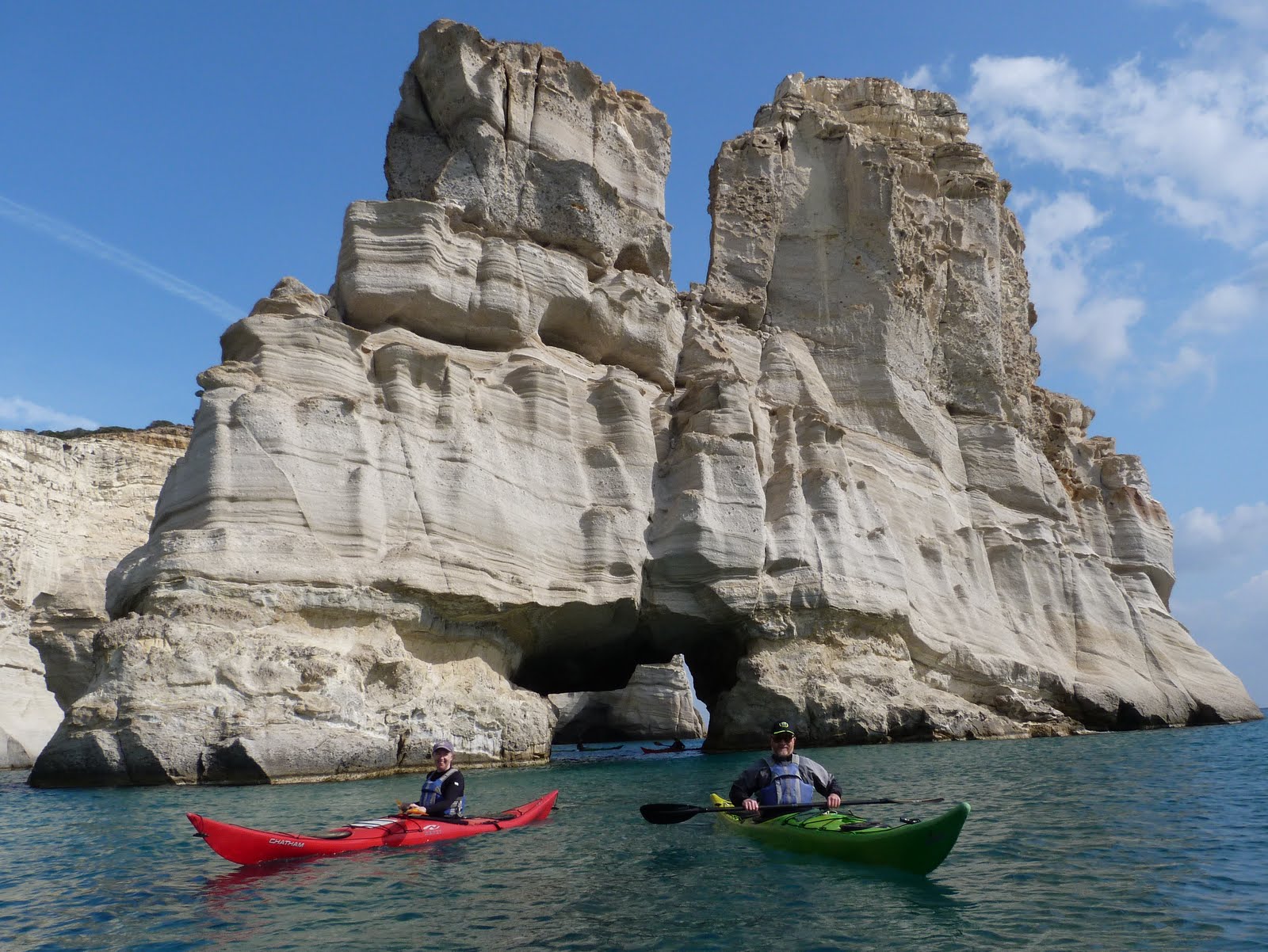
Milos Island, Greece


(Kayaking trip Guide)
Milos  is a volcanic Greek island in the Aegean Sea, just north of the Sea of CreteMilos Area also includes the uninhabited offshore islands of Antimilos and AkradiesMilos is the southwesternmost island in the Cyclades group.  From east to west it measures about 23 km, from north to south 13 km, and its area is estimated at 151 km² . The greater portion is rugged and hilly, culminating in Mount Profitis Elias 748 m  in the west. Like the rest of the cluster, the island is of volcanic origin, with tuff,trachyte and obsidian among its ordinary rocks. 
 Coastline:  
  • Length of Coast strip -93 км. 
  • Spectacular volcanic rock formations;
  • Sea caves, tunnels and arches;
  • Secluded and deserted  beaches;
  • Uninhabited islands.
Best Secuided Beaches to Camp
(Free and Wild Camping):   See   Map

Ithaka Island, Ionian Sea, Greece


(Kayaking trip Guide) 
Ithaca is one of the smaller Ionian islands, very close to East Kefalonia, with a great coastline and impressive to see from a kayak.  
There is a strait situated to the west of the island called the Strait of Ithaca. The capes in the island include Exogi, the westernmost but not in land, Melissa to the north, Mavronos and Agios Ilias to the east, Schinous, Sarakiniko and Agios Ioannis, the easternmost to the east and Agiou Andreou, the southernmost in the south. Bays include Afales Bay to the northwest, Frikes and Kioni Bays to the northeast and Ormos Gulf and Sarakiniko Bay to the southeast. The tallest mountain is Nirito (806 m), the second tallest is Merovigli (669 m).
Lazaretto Islet (or Island of The Saviour) guards the harbor. The church of The Saviour and the remains of an old gaol sit on the island
Coastline:  Length of Coast strip - 90 км.

Kefalonia, Southwest-West Coast - Part 5


(Kayaking trip Guide)
Area-From Cape Kakata to Lixouri 


Coastline: 
Length of Coast strip - 50 км. 
West  Coastline  - The most remote coastline in Kefalonia. Dramatic scenery, high limestone Cliffs, extensive rock Gardens, few but beautiful Beaches with mix of Pebble and  Sand.
Southwest Coastline: Clay Cliffs , many dark-red  coloured sandy public Beaches. 

Best secuided Beaches to Camp (Free Camping) Map 
Platia Ammos Beach 


Kayaking  Itinerary 1:  Xi Beaches - Petani Bay ;
Paddling Distance:24 км.
Duration: 6-9 hours 
Difficulty Level: Moderate to Difficult (in the usual weather conditions)
Coastline description: Dramatic scenery, Clay and high limestone Cliffs, Extensive rock Gardens, Few but beautiful Beaches with mix of Pebble & Sand.

Kefalonia, Northwest-West Coast - Part 4


Area-From Cape Dafnoudi to Cape Kakata
(Kayaking trip Guide)
Coastline:
            • Length of coast strip - 35 km.;
            • Main Beach area:  Assos - one of the most picturesque villages in the Ionians;
            • Myrtos, one of the most famous beaches in Greece
            • Dramatic high limestone cliffs;
  • Sea caves and rock gardens;
  • Remote beaches with a mix of sand and pebble;
  • Massive limestone walls in the northwest part of the coastline.

Kefalonia, East-North East Coast - Part 3

(Kayaking trip Guide)
Area-From Sami to Cape Dafnoudi
Coastline:
            • Length of Coast strip - 30 км.
            • Main Beach areas:  Sami, Agia Efimia, Fiskardo;
            • Over 90% of the coastline is remote;
            • Dozens of secluded Coves;
            • Pebble and Sand Beaches;
  • Forested hills, mainly cypress trees;
  • Views of Ithaca as the straight is only 2-3 miles wide;
Best Places to Camp (Free Camping):   Map

  • Kokongilos Beach; 

Kefalonia, East Coast - Part 2


(Kayaking trip Guide)


Area- From Skala to Sami
Coastline discription: 
Length of Coast strip is 36 км. 
Main Beach areas:  Skala, Poros, Antisamos, Sami. 
Over 90% of the coastline is remote with secluded coves and mostly pebble beaches. 
Georgeos forested hills and limestone rock formations. Coastline protected from storms.
Best Secuided Beaches to Camp (Free Camping): See large Map.

  • Kako Lagkadi Cove;
  • Lazarou Beach;
  • Koutsoupia Beach;
  • Platia Pounta Beach;

Kefalonia, South Coast - Part 1


(Kayaking trip Guide)
Area - from  Argostoli  to Katelios
Coastline:
  
            • Length of coast strip - 35 km.;
            • Main Beach areas:  Lassi, Lourdas BaySkala;
            • Coast strip with many sandy beaches; 
            • Many sea caves and arches;
            • White limestone cliffs and white-sand beaches;
            • Many access points.

Best Secuided Beaches to Camp (Free Camping):
  • Pessada Beach;
  • Some remote sandy beaches between Sissia and Koroni;
  • White Rocks beach (North  of Minia)

Zakynthos Island, Greece

(Kayaking trip Guide)
Zakynthos is the third largest Island in the Ionian Sea in Greece that covers an area of 410 sq. km and with a coastline of over 120 kilometers in length. Zakynthos  has  many sandy beaches with crystal blue waters, blue caves and it is very rich in sun... That' s why the island is one of the most beautiful and attractive travel destinations in Greece.The landscape of Zakynthos is diverse, there are fertile plains in the southeast, merging smoothly with quiet coves and golden beaches while the western part of the island's mountainous terrain is dominant and there are many cliffs along the coasts.The superb beaches of Zakynthos are famous  for their unspoiled beauty and their mirror-like emerald waters. The most famous beach of the island is:

Paxos Island, Greece

Paxos Island has not been infected by mass tourism. 

In there are about 30 beaches around Paxos. Most of them are on the the east coast. The  beaches on the spectacular west coast are mainly only accessible by water and here are also a number of magnificent caves.

North of Gaios are successively northward Kioni Gouli Beach, Kamini Beach and the sheltered beach Kaki Langada. 
Further on north ther are successively Alati Beach, Kipiadi Beach and Kipos Beach. On the other side of the cape, across the three tiny islets you will find Pigadi or Marmari Beach and Leverechia Beach. They are mostly pebble beaches.

Corfu Island,Greece


(Kayaking trip Guide) 
The greenest of all the Greek islands, Corfu's natural beauty is hidden under a cloak of emerald green, with a mountainous skyline plunging into the bluest of blue waters.
The weather conditions in the area are extremely favorable for a relaxing and trouble-free Kayaking. From May to September the wind blows from North-West at Force 2-5 arriving around noon, and calming down before sunset. In the morning it is also noticed that a light Easterly wind may blow at a force of 1-2. During the months of July and August, the above said winds can blow a little stronger than usual. 
Corfu is unique in providing so many diverse holiday locations. Its beaches are no exception, with long sweeping sandy bays, little rocky coves, or deserted bays. Corfu can easily offer you all of these beaches.
West wildest coastline of Corfu is the best to kayaking. There are at least a dozen perfect secluded beaches suitable for free camping.

Lefkada island, Greece


Top Kayaking Destination.


Lefkada Island is perfectly centered in the Ionian Sea and has many large islands surrounded by small islands all around. This leads to many hours of enjoyment for those who simply wish to relax and enjoy all that the water has to offer. Explore dramatic coastal cliffs, fascinating sea caves, unspoiled beaches  and turquoise bays of sparsely inhabited isles. Sleep on the beach and paddle along the  117 km. coastline of Lefkada. Site-seeing by kayak is an intimate and tranquil way to explore the less commercial and culturally rich Ionian Islands. 

Fiji Islands-Sea kayaking trip.


Fiji Islands offers sea kayakers warm clear water, awesome natural scenery, and friendly people. It's an especially good place for paddlers who also enjoy snorkeling or fishing.
The many Islands of Fiji are spread around the reef-strewn Koro Sea in the southwest Pacific Pcean. About 100 of over 300 islands are inhabited and range from large mountainous wooded landmasses to coral cays that can walk across with a few steps.
Here's a photo slideshow of one 4-day paddle I took last year:
John Caldeira

LinkWithin

Related Posts Plugin for WordPress, Blogger...